We decided to sail 400 nautical miles from Grenada north to the United States Virgin Islands. WHY? Bottom line, we wanted to reach an open airport. Radeen and I have been sailing and cruising Island Spirit since 2001. That is 19 years and we really love this life. At the same time, we have learned that taking a break off the boat is refreshing and renews our love of cruising. So, with the airport closed in Grenada and no information on when it would reopen, we took a weather window and set sail north.

The Route, Isla de Aves
When you plan the route from Grenada to St. Croix, the southern most US Virgin island, the course of 330 degrees sails very close to an island called Isla de Aves. Now, this looks like a great midway place to drop the hook and maybe take a rest in the lee of this sandy beach. WELL….hold on there, pirate….this island is owned by Venezuela and they are not too friendly to cruisers sailing in for a visit. Matter of fact, you are advised to stay well clear of this island or else the officials might divert your vessel into shore for an inspection. NO, THANK YOU! Here is the overview of the route.

With the winds at 090 blowing 20 knots gusting to 27 knots, we decided to set a waypoint almost 50 nautical miles SW of this island. That way, we could run a broad reach downwind to that point, 36 hours away. Then once made, turn due north on the lighter 15-20 knots of beam winds for 24 more hours to St. Croix. This is exactly what happened and exactly how it all worked out.
Thank you to weather routing by Chris Parker, see: https://www.mwxc.com/ who worked with us for two weeks to pick the best days to run. We told him we like to sail, not motor, and that 20-27 knots was OK with us downwind. We let the first window pass as the seas were 6-8 feet and the next one we took. This was one of the best sails in Island Spirit’s history! Here is a short video clip of autopilot set to wind angle hold. We love our B&G autopilot.
Life at sea
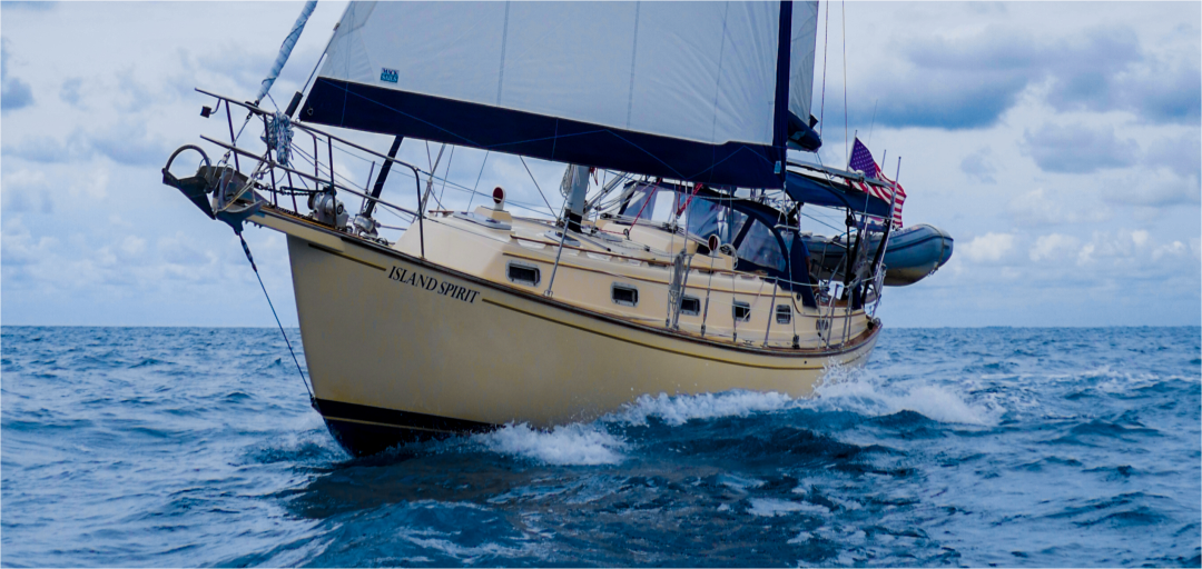
On a 400 nm run, this should take 3 days, with an expected 125 to 150 nm per day average run. So, we departed Grenada on Sunday May 17th, 2020 for our sail. With a full main and a full jib we reached beyond the lee of Grenada and soon were in the 20-25 knot winds. There we dropped in a single reef in the main and ran this all the way to sunset. At nightfall, we added a double reef in the main but kept the full 110 % jib flying strong. We were sailing at hull speed, which for an Island Packet 35 is 7.2 knots. We ran this way for 36 hours until we made our waypoint west of Isla de Aves. With just the two of us, we set a watch schedule as provided by our mentor, Captain Blaine Parks, as the best for two people:
- 0600-1200 Hayden
- 1200-1800 Radeen
- 1800-2100 Hayden
- 2100-2400 Radeen
- 0000-0300 Hayden
- 0300-0600 Radeen

Sunset was at 1830 and the tiny crescent moon rose at 0300 giving us very little light. These two nights at sea were the darkest nights we have ever sailed. No horizon at all, dim stars, and a black sea. The black night sky blended into the black sea and we were sailing hull speed, 7 knots, around the clock. The only two vessels we saw were a container ship bound for Aruba and two friendly fishermen on a brightly painted boat who pulled alongside and asked which way to Grenada! (This is not a joke – it was very hazy that morning and the island’s mountains were not visible from 17 miles northwest.)
Lucky for us, we have great faith in our B&G 4G digital radar where we set a watch guard 4-5 miles in front with a full circle around the boat 1 mile wide. If any solid object enters this zone, then an alarm goes off and a line on the screen points to the object. This is the only way we can feel safe that we will not hit something. Your mind really messes with you when tired at night going 7 knots full speed into the black. (Do not even let it go there, you need to stop all those crazy thoughts!)

See our recorded sailing speed
Whenever our boat moves, we turn on our Garmin Inreach satellite tracker. This device sends our position to a live map every 10 minutes and shows where we are. It also records this track as an archive map. We use another service called Spotwalla which actually does a better job than Garmin, because it allows you to create trip maps. Garmin just records it all and does not separate your travels.
When you go to our Garmin map, please first click the VIEW ALL button in the top right corner and then you can zoom out and see our travels. For this trip from Grenada to St. Croix, click on any point to see our recorded speeds. Remember, on this trip we did not motor, we sailed 99% of it, we motored the last hour to beat sunset. We also ran the motor one hour each night for hot water showers and for recharging the battery bank. Here is our Garmin Travel Map, so fun to study….https://share.garmin.com/islandspirit
PS: Speed was 400 nm in 60 hours = 6.7 knots for the trip!
Spotwalla, our Travel Maps
We love this fantastic free service (which I donate to yearly) called SPOTWALLA. This genius figured out a way to create individual travel maps as we run around with tracking devices. You can do all of this with your cell phone if you are always in touch with a cell tower. So, for ocean sailing we need the Garmin satellite tracker. For land adventures, you can easily create travel maps with this service. Here are ALL the maps we have made with Spotwalla… https://spotwalla.com/publicTrips.php?un=IslandSpirit35

Now…USVI for June
We are now in the United States Virgin Islands, where we can re-discover St. Thomas, St Croix and St John. In the 80’s and 90’s we took some of our summer and Christmas vacations here for a week of chartering. Now, we are staying a week on one mooring ball, swimming the crystal clear waters and learning the reefs in Christmas Cove, St. James Island. Next up, the National Park on St. John and St. Thomas, followed by a return to St. Croix.
After June, we will move over to Fajardo, Puerto Rico and prepare for our haulout at Puerto Del Ray Marina. YES, we know this places us back into hurricane zone and, yes, we recall our previous hurricane damages there. Because we want to be in the Caribbean next season, we decided this was our best option to reach a working airport, where we know we can fly out and, more importantly, we can fly back to our boat. For now….let’s enjoy the USVI.
Here are some photos to show why we enjoy being here


Thank you for following, see our public Facebook Page
Please like and follow us on our public Facebook page here. We often post there and we love to hear from you all, Please leave us a comment, they are sent to us in email immediately. Stay safe everyone.
https://www.facebook.com/svIslandSpirit/


